12.25.2010
11.26.2010
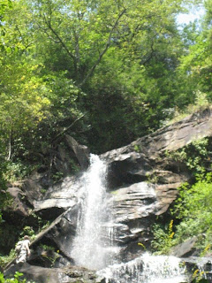
daniel creek falls
x3 upper / middle / lower --- #30, 31, 32
 Visited: 11/26/10
Region: Dade County - Cloudland Canyon SP
Water Body: Daniel Creek
Accessibility: strenuous (3)
Type: cliff
Primary Rock: unknown (flagstone?)
Height: ^/150', =/150', v/15'
Flow: normal/humming (4)
Awe Factor: impressive (3)
Cavity Access: yes
Companions: Rebecca Link
Foot Travel: trail/3mi
Elevation: 1720'
Grid Location: N34°50.07' W85°28.90'
upper daniel creek falls
[insert story - few people - cold day]


From left to right: teir 1/lower falls, middle falls, middle falls, newt found at upper falls


From left to right: upper falls, teir 1/lower falls, teir 2/lower falls, teir 2/lower falls
11.25.2010
keown falls
 #29
#29Visited: 11/25/10
Region: Walker County - Keown Scenic Area - John's Mountain - Chattahoochee NF
Water Body:
Accessibility: strenuous (3)
Height: 50'
Type: overhang
Primary Rock: granite
Flow: very low/trickle (2)
Awe Factor: impressive (3)
Cavity Access: yes
Companions: solo
Foot Travel: trail/4mi
Elevation: 1400'
Grid Location: N34° 36.80' W85° 05.70'
Companions: solo
Foot Travel: trail/4mi
Elevation: 1400'
Grid Location: N34° 36.80' W85° 05.70'
keown falls
[insert story - no people - spray-paint/vandals signs]


From left to right: trail leading to falls, looking up from base, empty falls, keown falls
10.09.2010
blood mountain falls
x3 lower / middle / upper --- #26, 27, 28
 Visited: 10/9/10
Region: Lumpkin County - Chestatee WMA - Chattahoochee NF
Water Body: Blood Mountain Creek
Accessibility: strenuous (3)
Type: v/bottleneck, =/veil, ^/stair
Primary Rock: granite
Height: v/25', =/50', ^/150'
Flow: normal/humming (4)
Awe Factor: amazing (5)
Cavity Access: no
Companions: Tommy & Daisy Swetman (lower/middle), solo (upper)
Foot Travel: v/= drive to/dirt road, ^ trail/4mi
Elevation: lower/middle 1980', upper 2260'
Grid Location: v/= trailhead - N34° 41.87' W83° 57.18', ^ trailhead - N34° 42.4' W83° 57.3'
upper blood mountain falls
[insert story here - no people]
Visited: 10/9/10Region: Lumpkin County - Chestatee WMA - Chattahoochee NF
Water Body: Blood Mountain Creek
Accessibility: strenuous (3)
Type: v/bottleneck, =/veil, ^/stair
Primary Rock: granite
Height: v/25', =/50', ^/150'
Flow: normal/humming (4)
Awe Factor: amazing (5)
Cavity Access: no
Companions: Tommy & Daisy Swetman (lower/middle), solo (upper)
Foot Travel: v/= drive to/dirt road, ^ trail/4mi
Elevation: lower/middle 1980', upper 2260'
Grid Location: v/= trailhead - N34° 41.87' W83° 57.18', ^ trailhead - N34° 42.4' W83° 57.3'
upper blood mountain falls
[insert story here - no people]


from left to right: middle falls, middle falls, lower falls, lower falls


from left to right: lower falls, upper falls, cubby hole at upper falls
dicks creek falls
x2 upper / lower --- #24, 25
 Visited: 10/9/10
Region: Lumpkin County - Chestatee WMA - Chattahoochee NF
Water Body: Dicks Creek
Accessibility: easy (1)
Type: ^/bottleneck, v/block
Primary Rock: granite
Height: ^/15', v/15'
Flow: normal/humming (4)
Awe Factor: boring (2)
Cavity Access: no
Companions: Tommy & Daisy Swetman
Foot Travel: none/drive to/dirt road
Elevation: 1740'
Grid Location: N34°40.78' W83°56.20'
[insert story - crowded with foreigners and children]
 Visited: 10/9/10
 Region: Lumpkin County - Chestatee WMA - Chattahoochee NF
Water Body: Dicks Creek
Accessibility: easy (1)
Type: ^/bottleneck, v/block
Primary Rock: granite
Height: ^/15', v/15'
Flow: normal/humming (4)
Awe Factor: boring (2)
Cavity Access: no
Companions: Tommy & Daisy Swetman
Foot Travel: none/drive to/dirt road
Elevation: 1740'
Grid Location: N34°40.78' W83°56.20'
Lower Dicks Creek Falls
[insert story - crowded with foreigners and children]


From left to right: upper Dicks Creek Falls, upper Dicks Creek Falls, connecting run, lower Dicks Creek Falls
9.17.2010
cochrans falls
#22
 Visited: 9/17/10
 Visited: 9/17/10
Region: Dawson County - Blue Ridge WMA - Chattahoochee NF
Water Body: Cochrans Creek
Accessibility: dangerous (5)
Type: cliff, block, veil, bottleneck
Primary Rock: granite
Height: 600'
Flow: normal/humming (4)
Awe Factor: phenominal (6)
Cavity Access: no
Flow: normal/humming (4)
Awe Factor: phenominal (6)
Cavity Access: no
Companions: Martin Ade, Tommy Swetman, Adam Stubbs
Foot Travel: on trail/4mi
Elevation: 1900'
Foot Travel: on trail/4mi
Elevation: 1900'
Grid Location: base of falls - N34º34.52' W84º12.97'
Cochrans Falls
[insert story - void of people]


Left to right: Cochrans Falls (bottom), Cochrans Falls (mid-way), Cochrans Falls (looking to top)


Cochrans Falls (top)
9.05.2010
julie anna falls
 #22
#22Visited: 9/5/10
Region: Gilmer County - Rich Mountain Wilderness - Chattahoochee NF
Water Body: Turniptown Creek
Accessibility: moderate (2)
Type: cliff
Primary Rock: granite
Height: 50'
Flow: very low/trickle (2)
Awe Factor: inspiring (4)
Cavity Access: no
Companions: solo
Foot Travel: on trail/4mi
Elevation: 2820'
Grid Location: N34°44.05' W84°21.10'
Julie Anna Falls
[insert story - void of people]


Julie Anna Falls, old logging road leading to falls
9.04.2010
barnes creek falls
#21
 Visited: 9/4/10
Region: Gilmer County - Cohutta WMA - Chattahoochee NF
Water Body: Barnes Creek
Accessibility: easy (1)
 Visited: 9/4/10
Region: Gilmer County - Cohutta WMA - Chattahoochee NF
Water Body: Barnes Creek
Accessibility: easy (1)
Type: block
Primary Rock: granite
Height: 100'
Flow: very low/trickle (2)
Awe Factor: boring (2)
Height: 100'
Flow: very low/trickle (2)
Awe Factor: boring (2)
Cavity Access: no
Companions: solo
Foot Travel: none/4x4 dirt road
Elevation:
Grid Location: N34°49.57' W84°34.94'
Barnes Creek Falls
Companions: solo
Foot Travel: none/4x4 dirt road
Elevation:
Grid Location: N34°49.57' W84°34.94'
Barnes Creek Falls
[insert story - crowded with SUV moms and their screaming offspring]


Barnes Creek Falls
8.20.2010
sea creek falls
 #20
#20Visited: 8.20.2010
Region: Fannin County - Coopers Creek WMA - Chattahoochee NF
Water Body: Sea Creek
Accessability: moderate (2)
Type: shelf
Primary Rock: granite
Height: 30'
Flow: normal/humming (4)
Awe Factor: boring (2)
Cavity Access: no
Companions: Martin Ade
Foot Travel: on trail/2mi
Altitude:
Grid Location: [not available]
Companions: Martin Ade
Foot Travel: on trail/2mi
Altitude:
Grid Location: [not available]
Sea Creek Falls
[insert story here - no people, but littered with white trash & redneck residue]
 Sea Creek Falls
little rock creek falls
#19
 Visited: 8.20.2010
Region: Fannin County - Blue Ridge WMA - Chattahoochee NF
Water Body: Little Rock Creek
Accessability: moderate (2)
Type: cliff, block
Primary Rock: granite
Height: 50'
Flow: normal/humming (4)
Awe Factor: inspiring (4)
Cavity Access: yes
Companions: Martin Ade
Foot Travel: on trail/2mi
Altitude:
Grid Location: [not available]
Little Rock Creek Falls
[insert story here - void of people]


Little Rock Creek Falls
noontootla falls
#18
 Visited: 8.14.2010 & 8.20.2010
Region: Fannin County - Ed Jenkins NRA - Blue Ridge WMA - Chattahoochee NF
Water Body: Branch on Noontootla Creek
Accessability: dangerous
Type: blanket, block, cliff
Primary Rock: granite
Height: 500'
Flow: low/babbling (3)
Awe Factor: inspiring (4)
Cavity Access: no
Companions: Matt Walker 8/14, Martin Ade 8/20
Foot Travel: off trail/.5mi
Altitude:
Grid Location: [not available]
Noontootla Falls
[insert story here - void of people]


From left to right: the view from the top, Noontootla Falls
long creek falls
x3 lower / middle / upper --- #1, 2, 3

Visited: ca. 2.06 & 8.20.10
Region: Fannin County - Appalachian Trail - Blue Ridge WMA - Chattahoochee NF
Region: Fannin County - Appalachian Trail - Blue Ridge WMA - Chattahoochee NF
Water Body: Long Creek
Accessability: moderate (2)
Accessability: moderate (2)
Type: cliff, block
Primary Rock: granite
Height: v/20', =/20', ^/30'
Flow: high/above average (5)
Awe Factor: impressive (3)
Height: v/20', =/20', ^/30'
Flow: high/above average (5)
Awe Factor: impressive (3)
Cavity Access: no
Companions: Thomas Swetman('06), Martin Ade ('06, '10)
Foot Travel: on trail/2mi
Companions: Thomas Swetman('06), Martin Ade ('06, '10)
Foot Travel: on trail/2mi
Altitude:
Grid location: [not available]
Upper Long Creek Falls 8.20.10
[occasional trail hippie] - These falls are where it all began during a cold and snowy camping trip at Hickory Flats Cemetary in Feburary of 2006. Myself and two buddies blindly wandered off into the forest hoping to pick up the AT. After about an hour of what seemed to be mindless walking through the snow, we came upon these falls. The winter picture below was taken during that nomadic venture. Four years later, when I initiated my cascading bucket list, I returned to the falls with one of those friends to call it my starting point and take a more usable picture for this blog (seen above). Along the way we came across a lower and middle falls on Long Creek that, as far as I know, remain unamed. I'm just going to assume they're the lower/middle Long Creek Falls. These first two falls are well worth seeing, as they are off the path and show very little foot traffic, whereas the upper most falls is well traveled. I plan on visiting this site every year with those same friends with whom I first stumbled upon this little gem just off the beaten path.
[occasional trail hippie] - These falls are where it all began during a cold and snowy camping trip at Hickory Flats Cemetary in Feburary of 2006. Myself and two buddies blindly wandered off into the forest hoping to pick up the AT. After about an hour of what seemed to be mindless walking through the snow, we came upon these falls. The winter picture below was taken during that nomadic venture. Four years later, when I initiated my cascading bucket list, I returned to the falls with one of those friends to call it my starting point and take a more usable picture for this blog (seen above). Along the way we came across a lower and middle falls on Long Creek that, as far as I know, remain unamed. I'm just going to assume they're the lower/middle Long Creek Falls. These first two falls are well worth seeing, as they are off the path and show very little foot traffic, whereas the upper most falls is well traveled. I plan on visiting this site every year with those same friends with whom I first stumbled upon this little gem just off the beaten path.
Although we first encountered Long Creek Falls starting from Hickory Flats, I'd recommend accessing the AT at the Three Forks intersection across the road from where the trail crosses Noontootla Creek. It's easily reached by car, and only about a mile hike up the trail from there.


From left to right: Upper Long Creek Falls ca. 2.06, Lower Long Creek Falls 8.20.10, Middle Long Creek Falls 8.20.10
Subscribe to:
Comments (Atom)